J. K. Barbalace, inc
Custom Website & Database Application Development
Database Application Development
 We provide database design and development services for the Microsoft SQL, Microsoft Access and MySQL environments. Our flexibility and experience allows us to create a database solution to suit our customers needs, whether the requirement is for: a MS-Access solution with only a few users in a LAN or single computer environment; a MS-SQL back end with MS-Access client side front-end for a large number of users in a LAN/WAN environment; or a MS-SQL, MS-Access or MySQL back-end with a webpage front-end for an intranet/Internet solution.
We also offer fast turn around for small Microsoft Access database projects. In some instances for really small projects the turn around can be as little as a few days. On site service is offered in the Southern Maine (Cumberland and York counties).
Featured Project
Cumberland County SWCD - Watershed Management
(Mobile device optimized web based database application)
CCSWCD testimonial (PDF - 365KB)
CCSWCD brochure promoting services that rely on this web app (PDF - 2.27 MB)
We developed a web based database application using a LAMP (Linux, Apache, MySQL and PHP) solution, and provide continuing support for Cumberland County Soil and Water Conservation District (CCSWCD). This complex property database was necessary to support the Long Creek Watershed Management District's implementation of the Long Creek Watershed Management Plan. Following successful implementation in the Long Creek Watershed, the database was expanded to provide a means of managing other watersheds within the Interlocal Stormwater Working Group (ISWG). The database includes property information such as parcel features, impervious areas, GPS location of stormwater control devices (storm drains, culverts, swales, etc.) and property owners and operators. It facilitates the tracking of treated impervious areas, device performance and maintenance needs throughout the watershed. When conducting field inspections, the web app provides inspectors with a list of devices they are physically closest to by way of the GPS coordinates their tablet, iPad, etc. provides to the web application. Users are also able to open GPS/GIS data directly from the website into Google Earth (even on their mobile devices) via KML overlays and again access the site directly from Google Earth using those same KML overlays. Additional functionality this web application provides includes: landowner invoicing; property inspections & inspection reporting; tracking of storm water infrastructure and management on a watershed-by-watershed and town-by-town basis throughout ISWG's 14 member-municipalities.
This web based database application is designed to W3C HTML and CSS specifications and supports any standards compliant web browser. It is also optimized for use on Android tablets, iPads and other mobile devices that have a standards compliant web browser. As this web app is standards based, member municipalities and inspectors are able to use their preferred Internet capable computing devices and don't necessarily have to purchase special equipment to access this web based database application. This database application utilizes PHP, MySQL, HTML, XML, KML, CSS and JavaScript.
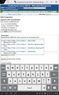
NOTE: This web based database application is not accessible by the general public. In person demonstrations of this application can be arranged. Please click on the thumbnail to the right to see a larger sample screen capture from a Samsung Galaxy Tab running Firefox Mobile of a BMP (best management practices) inspection being initialized by selecting area to be inspected based on the user's GPS coordinates.
